 Dr. Scott Marshall, our resident geophysicist whose research involves fault modeling and how earthquakes occur, has provided the answers to some common questions about the recent earthquakes around Sparta, NC, Blowing Rock, NC and the possibility of other earthquakes along the East Coast and in the southern Appalachians.
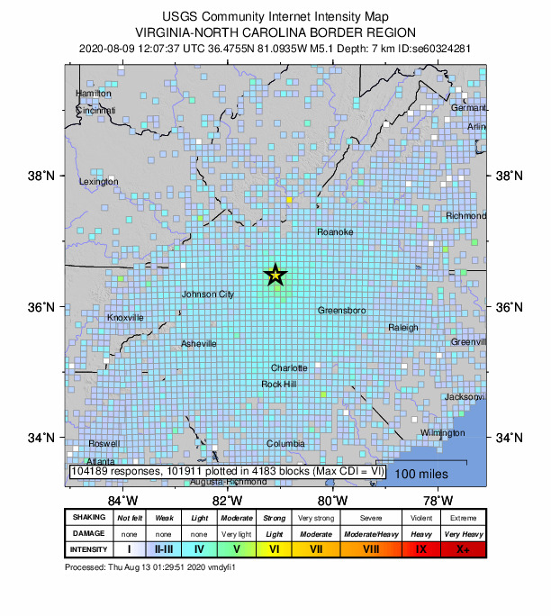
On August 9, 2020, many of us in the region felt the Magnitude 5.1 earthquake in Sparta, NC at around 8 am.
Very little is clear about this event except that it appears to have occurred on a NNW-trending reverse fault. We feel earthquakes on the east coast a lot further from their epicenter compared to the west coast, because the crust is older and colder, and waves can travel through it more efficiently. As you can see from the USGS Intensity (Modified Mercalli) scale map below, the effects were felt quite far away. Every time you feel an earthquake, it's very important to go to the USGS's Did You Feel It? page and report your observations so we can develop better models for earthquakes in areas where they are less common.
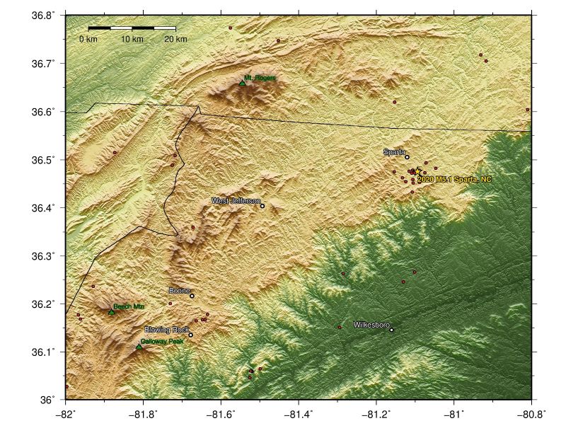
Will there will be aftershocks? The answer is yes. Aftershocks tend to be smaller (but not always) in magnitude than the original event, but if they are shallower they can feel stronger than one may expect. How long aftershocks continue depends on the size of the causative earthquake and the background regional earthquake rate. In other words, larger events have more aftershocks for longer, and aftershocks decay faster with time in regions that have more earthquakes. So, in the Eastern US where the normal earthquake rate is slow, aftershocks continue for longer times than, say, in California where there are typically more earthquakes. Some aftershocks have happened already, as you can see in the image below:
Are these earthquakes common? Although earthquakes of this magnitude are rare in the southeastern US, they are not unheard of. The map below shows numerous earthquakes throughout western NC and the southern Appalachians with several damaging historic events labeled with gold text and stars. The zone of earthquakes just to the west of us is called the East Tennessee Seismic Zone, and not a lot is known about that yet because most of these earthquakes have been very small (< M2).
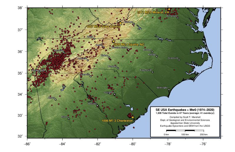
Why did this earthquake happen? The overall take-home message is that while events like the M5.1 Sparta earthquake are not common, this is not actually unheard of and events like this have happened in the past in our region. As the earth's lithosphere shifts through plate tectonics, even the interiors of plates can build up stress. In areas with lots of old faults, like the Appalachians, we tend to get earthquakes along pre-existing fault zones that have weakened rock at depth. Even though the southern Appalachians are not currently at an active plate boundary, our tectonic history means that built-up stresses from time to time are able to be released along old faults from the building of the Appalachians, which happened hundreds of millions of years ago.
Could the M5.1 Sparta earthquake lead to or trigger a larger earthquake in the future? We know that earthquakes can trigger other earthquakes. For example the 2019 Ridgecrest, CA earthquake sequence started with a M6.4 event that pretty clearly triggered a M5.4 and M7.1 event a day later. So, while it is possible, most earthquakes do not trigger subsequent larger events.
Still want to learn more? Check out the InSAR interferogram created by quantitative geoscience alumn Hugh Harper (GES'15).
Back on August 24, 2014, we also experienced the Magnitude 2.4 earthquake between Boone and Blowing Rock, NC at around 7 pm.
We had an earthquake occur almost exactly a year before this in the same place. Is this a coincidence?
My opinion (based on very little data) is that this event is an aftershock related to the M2.9 event that happened in the same place last August.
Here's why I come to this conclusion:
- We have had several events since the M2.9 event in Aug 2013 (see the summary below), and they all are located near the original M2.9 event. Although I admit that locations of earthquakes in the East US is very loose.
- These events have all been smaller than the mainshock (M2.9)
- Earthquake aftershocks decay rate depends on background seismicity rate. So in simple terms this means that if two equal sized earthquakes were to happen, one in California and one here, the aftershocks in CA would happen much closer in time and decay away faster than the events here. This is because the region is more active and subsurface rocks are weaker (more damaged/faulted) out west, so re-adjustments can happen much quicker. This is supported by tons of seismic data for numerous events. To put things in perspective, some folks have argued that the current day earthquakes in the New Madrid region are still aftershocks from the several M7-8 events in 1811-1812.
How can I learn more?
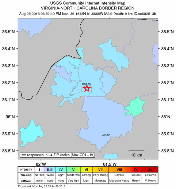
The United States Geological Survey (USGS) has the most up-to-date information on all US Earthquakes. The most recent Blowing Rock, NC information is located here, while the earthquake information from 2013 is here. One thing you can do is to fill out a "Did You Feel It?" report on the web, which is how the USGS makes isoseismal maps (maps of equal shaking intensity - click on the map of Boone with the colored patches on it, below). The maps can't be made if people don't fill out the reports. Just click on the map and then click "Did you feel it? - Tell Us!" and contribute to the map-making process!
Dr. Marshall's original interview about the August 25, 2013 Magnitude 2.9 earthquake between Boone and Blowing Rock, NC is given below.
We don't often get earthquakes in our area. Why did this one occur where it did?
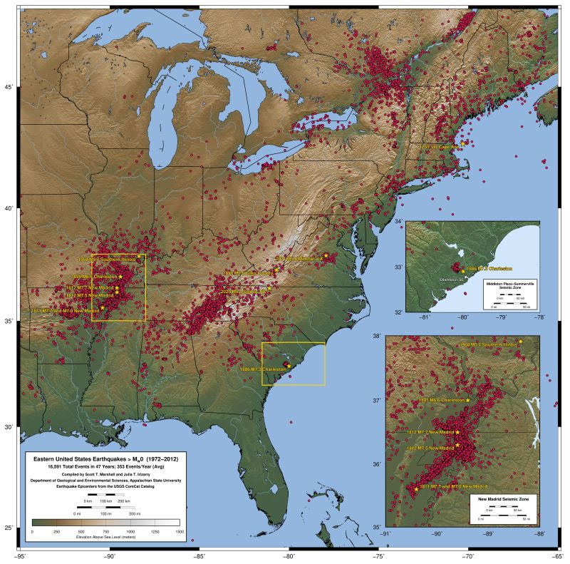
Looking at the map with all the earthquake locations shown with red dots (click map for larger image), you can see a diffuse belt of seismicity that generally follows the Appalachian Mountains. These earthquakes are probably due to slip on reactivated faults in the Appalachians including old thrust faults (from Africa's collision with us) and old normal faults which were active during rifting when Africa split off from us. You may notice an area of increased seismicity just west of us. This is called the Eastern Tennessee Seismic Zone, and we don't know very much about it yet. Julia Irizarry '13, a quantitative geoscience major in the GES Department, compiled this map of East Coast seismicity as part of her independent research (this has now been updated with 2020 data to reflect the most recent earthquake).
Even though this region is not on an active plate boundary (such as the San Andreas Fault, where the North American and Pacific plates are sliding past one another), we can still have motion within a plate. Many earthquakes in the eastern U.S. may be due to ridge push from the Mid Atlantic Ridge, which is pushing the North American plate westward. The North American plate mostly just moves as a rigid block, but sometimes it will slip along weak spots (old faults) due to the westward-directed push (i.e. EW compression).
There is not enough known yet about this particular earthquake to be able to say in which direction the causative fault slipped or why it slipped the way it did. In fact, we may not ever get a reliable focal mechanism or moment tensor from the event because the event was very small and there are far fewer continuously operating seismometers in the eastern U.S. Even the epicenter location is not all that well constrained because locating earthquakes requires multiple seismometers and an accurate and detailed seismic velocity model, which does not exist for our region.
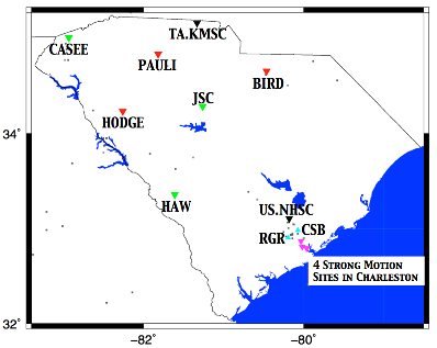
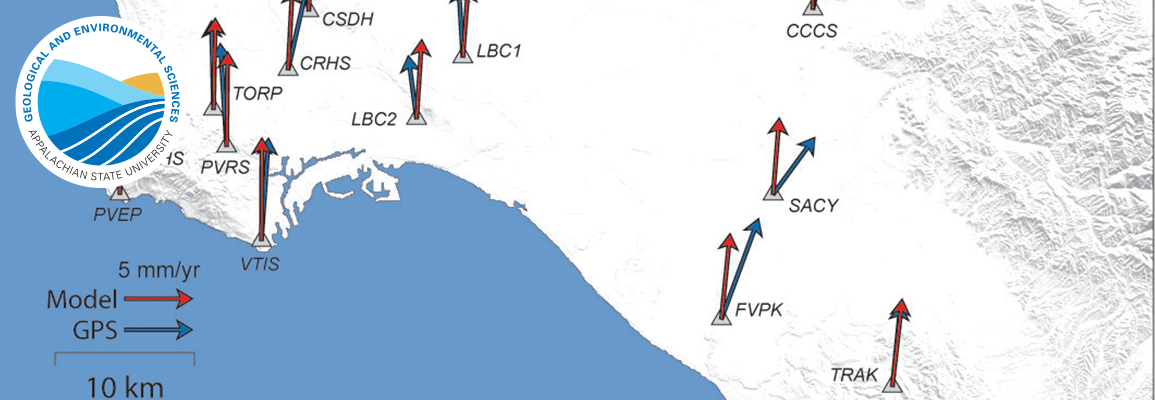
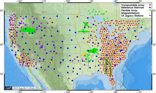
Triangulation of the epicenter was calculated with 14 seismometers in the South Carolina Seismic Network (SCSN) (see map of S. Carolina to the right) and other networks, but the lack of accurate seismic velocity data for this region means that the epicenter can only be located within probably +/- a few kilometers. That’s a lot of error! The National Science Foundation has funded a large project called USArray (http://www.usarray.org/) that is focused on better understanding the deep subsurface structure of the United States. The cool thing is that the USArray is currently in our neck of the woods (see the red dots on the USArray map below), so maybe we will get some high quality data from this event!
That earthquake was not very strong and didn't last very long, so why did so many people feel it?
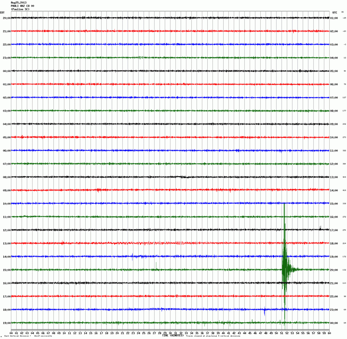
The shaking was very short (1-2 sec), but surprisingly intense for a M2.9, perhaps because this event was very shallow (9 km). Small earthquakes like this one are common in the east US (recall the 2011 M5.8 earthquake in Virginia). Furthermore, earthquakes away from plate boundaries are felt over distances up to 10x farther than equivalent earthquakes at plate boundaries with lots of broken rocks. This is due to slow wave attenuation in the less broken rocks in the east US. You can see an animation of the seismographs that recorded the earthquake from the SCSN in the image below (look for the spikes on the green line near the bottom of the image). All seismograms were pulled from (http://www.seis.sc.edu/projects/SCSN/) on 08/25/2013. Note that station CSB (near Charleston, SC) apparently did not register the event. This could be because that seismometer is somewhat noisy, or just the simple fact that this was a very small event and that station is rather far from the epicenter.
Why can't we see the fault on the surface?
Earthquakes in the eastern US almost never have surface rupture because even if they are moderate in size, the causative faults are all blind and mostly occur within deep basement rock. Typically only moderate to large earthquakes rupture all the way up to the surface of the Earth.
That map shows a lot of earthquakes - how does it compare to other parts of the US?
For a similar period of time in ONLY southern California there were more than 400,000 earthquakes, while Julia's map of the entire eastern US has 13,360. That puts things into perspective. You can see a map of southern California earthquakes or northern California earthquakes on my web site. Also, keep in mind that there are literally hundreds to thousands of earthquakes in the United States recorded by seismometers every day. The USGS posts information about all recorded events here
The Mineral, VA earthquake in 2011 also occurred in late August. Is there a pattern here?
That's very unlikely. While we cannot say for certain that this event will lead to anything much bigger, it is statistically unlikely that it is a precursor to a larger event to come. Scientists have done numerous studies and have shown that in most regions on Earth, there is no correlation of earthquakes with time of year.
How many people felt this earthquake?
The Blowing Rock, NC information is located here. The USGS needs people to fill out "Did You Feel It?" reports via the web in order to make their isoseismal maps (maps of equal shaking intensity - click on the map of Boone with the colored patches on it, below). The maps can't be made if people don't fill out the reports, so if you feel an earthquake make sure to report it to the USGS!