
Hugh Harper is a 2015 graduate of the GES Quatitative Geoscience program and is currently making us proud as a PhD candidate at Scripps Institute of Oceanography in La Jolla, CA. Over the past couple of weeks he has spent his free time learning InSAR (which usually takes months to learn) in order to process and create an interferogram of the recent, August 9th earthquake in Sparta, NC. Mr. Harper is originally from Sparta and his family lives there. The event caused some damage to the foundation of their family home.
Dr. Marshall and Mr. Harper explain what the interferogram shows below.
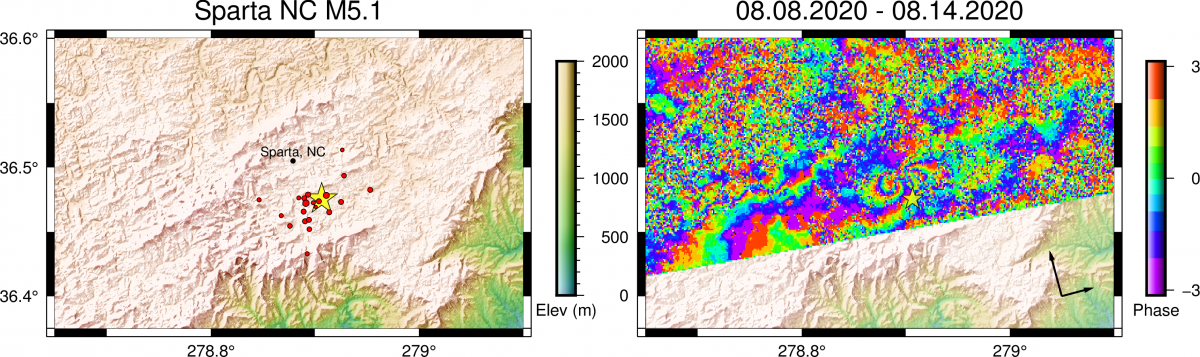
The left map shows all >M1 earthquakes since the August 8th M5.1 Sparta, NC earthquake. The star shows the epicenter.
The right map shows an interferogram formed by data collected by the Sentinel 1 satellite. The interferogram uses the difference between two repeat satellite images to reveal permanent ground motion in response to the M5.1 Sparta, NC earthquake. The radial “fringe” pattern northwest of the located epicenter is typical for earthquakes that are blind (do not rupture the surface of the Earth) and indicates mostly ground motion away from the satellite, or subsidence, of about 5 cm. A related set of fringes, just north of the epicenter, indicates uplift. This is also typical because opposing sides of a fault move in opposite directions. Outside of these fringes, the two satellite images are decorrelated (i.e. look like random noise), due to the high degree of vegetation in the region.